Superstorm Sandy 10-year anniversary: Why the 2012 superstorm was so destructive in the Northeast
The New York City tri-state area and the Jersey Shore were struck by the core of Sandy, but the superstorm’s effects extended thousands of miles away from its center. Heavy snow buried the mountains of West Virginia as severe thunderstorms stretched from Massachusetts to Montreal, Canada.

10 years after Superstorm Sandy: Some homeowners asked to give money back
Saturday is the 10-year anniversary of Superstorm Sandy, and some homeowners are still trying to recover from the historic storm. Special grants and loans from the government have helped people living along coastal communities in New York and New Jersey rebuild. But now, some people are being asked to give some of that money back. FOX News correspondent Laura Ingle has details on this new challenge Sandy victims face.
Ten years ago, Superstorm Sandy crashed ashore near Atlantic City, New Jersey, on Oct. 29, 2012, killing more than 100 people and causing billions of dollars in damage.
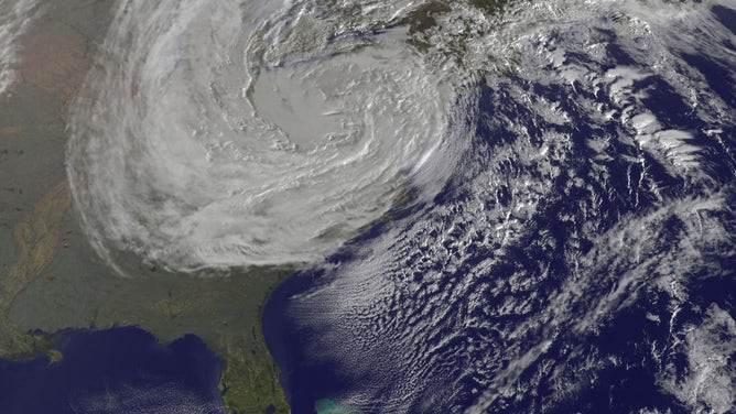
The Geostationary Operational Environmental Satellite 13 (GOES-13) captured this natural-color image of Hurricane Sandy at 1:45 p.m. Eastern time on Oct. 28, 2012. Note how a line of clouds from a continental weather system runs south to north along the Appalachian Mountains, approaching from the west to meet the offshore storm.
(NASA/NOAA)
Sandy originated as a tropical disturbance that organized into a tropical depression on Category 3 major hurricane by the time it made its next landfall in eastern Cuba.
ATLANTIC HURRICANE SEASON CAN REMAIN ACTIVE IN OCTOBER WITH POTENTIAL U.S. THREATS
From there, Sandy weakened to a prevailing winds that blow from west to east between 30 and 60 degrees latitude – tend to increase as the atmosphere begins its transition from
This map illustrates the weather pattern that steered Hurricane Sandy toward the New Jersey coast.
(FOX Weather)
"That combination of the ridge in the North Atlantic, with its clockwise motion around it, and the trough coming in, which brings kind of counterclockwise winds with it, was essentially serving as both a push and a pull for that storm as it came up the coast," said
The tracks of Hurricane Irene in 2011 and Hurricane Floyd in 1999 along the mid-Atlantic and Northeast coasts.
(FOX Weather)
"But to see one come up the coast and then hang a left and head into the mainland is climatologically quite unusual," Robinson said.
Sandy stubbornly hangs onto hurricane status until final hours
Many forecasters believed the combination of the trough over North America and the time of the year (late October) would cause Sandy to lose its tropical characteristics and transition into a system more typical of a WHAT'S THE DIFFERENCE BETWEEN A NOR'EASTER AND A HURRICANE?
"Ultimately, it was only about two to three hours before it made landfall in New Jersey that it was declassified as a hurricane," Robinson said. "It stayed a tropical system – a hurricane – farther north than originally anticipated."
This GOES-13 satellite image was captured on Oct. 31, 2012, at 8:40 a.m. Eastern time as Sandy's circulation was winding down over Pennsylvania. Sandy had been downgraded a remnant low pressure area.
(NASA GOES Project)
Storm surges reached over 12 feet
The New York City tri-state area and the Jersey Shore were struck by the core of Sandy, but the superstorm’s effects extended thousands of miles away from its center.
"The winds were blowing over such a huge expanse of the western Atlantic that, as a result, it was pushing water up against the Jersey coast, New York, into southern Connecticut and Long Island Sound, equivalent of what would be a
The Star Jet roller coaster fell into the water after the Casino Pier it sat on collapsed from the forces of Superstorm Sandy in Seaside Heights, New Jersey.
(Mark Wilson / Getty Images)
When adjusted for inflation, the superstorm was responsible for on Saturday and Sunday at 8 p.m. and 11 p.m. Eastern on FOX Weather.